

Wind LiDAR
SWTS specializes in advanced Wind LiDAR solutions for accurate wind measurement and analysis in onshore and offshore wind projects. We provide reliable data to support wind resource assessment, optimize project performance, and enable sustainable renewable energy development.
Vision & Mission
Vision
Laser Remote Sensing to empower green, safe, and highquality development.
Mission
To be the Leader of "Ground-Ocean-Air-Space" Remote Sensing LiDAR Technology.

Technical Advantage
Specialized LiDAR Signal Processor
The signal processors developed by Leice Transient offer highly integrated, miniaturized, architecture with low power consumption and fast, accurate data retrieval.
Single-Frequency Pulsed Fiber Laser
World-class fiber laser technology with high spectral purity and ultra-low RIN noise, minimizing nonlinear effects for stable, high-performance LiDAR operation.
Advanced Inversion Algorithms
Backed by 30+ years of algorithm development, our AIdriven inversion algorithms tackle complex applications with precision and adaptability
Agile Delivery and Engineering Support
Strong manufacturing capacity, full stack knowhow and responsive team, we ensure fast delivery, customization, and reliable technical support tailored to client needs.
Working Principle of Wind Lidars

Emitting Laser Pulses
Wind lidar systems utilize a pulsed laser that emits short bursts of light, typically in the infrared spectrum. The laser beam is sent out into the atmosphere, where it reflects off of particles in the air. These particles can be anything from dust and pollen to water droplets and aerosols.
Measuring the Time of Flight
The distance between the lidar and the reflecting particles can be determined by measuring the time it takes for the laser pulse to bounce back to the lidar. By measuring this time of flight, the lidar can determine the distance between itself and the reflecting particles.

Calculating Wind Speed and Direction
As the lidar moves or the atmosphere changes, the particles in the air move with the wind. By tracking the movements of these particles over time, the lidar can calculate the speed and direction of the wind at different heights in the atmosphere.
Analyzing Data
The data collected by the wind lidar is typically used to create a detailed map of wind speeds and directions. This data can be used for a variety of purposes, such as predicting weather patterns, optimizing wind turbine efficiency, or studying atmospheric physics.

Powering Wind Intelligence Across Industries


Wind Engergy
Resource assessment, power
curve prediction, farm
optimization
Environment
Air quality evaluation, pollution
tracking, wildfire detection
Meteorology
Wind engineering,atmospheric dynamics, climate
studies
Aviation Safety
Wind shear detection, wake
vortex monitoring, visibility
Why Accurate Wind Measurement Matters
Inaccurate Wind
Resource Assessment
Tough ocean weather makes wind hard
to predict. Real output often falls short
of forecasts, cutting into returns.
Significant Power
Forecasting Deviation
Inaccurate forecasts hurt accuracy of
power forecast. This means more
uncertainty in energy trading and loss
of income
Yaw, Wake, and Load Effects
Impact
They wind farm operation inefficiencies
from the inaccurate measurement may
cause 2–5% losses from yaw error, 5–
15% from wakes, and 3–5% higher
turbine stress


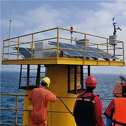
Vertical Wind Profiler: WP 350 / WP350 MB

Technical Specifications
-
Detection Range: 10 m – 350 m
-
Wind Speed Measurement Range: 0 – 75 m/s
-
Wind Direction Measurement Range: 0 – 360°
-
Wind Speed Measurement Accuracy: ≤ 0.1 m/s
-
Wind Direction Measurement Accuracy: ≤ 1°
-
Maximum Wind Resistance: ≤ 60 m/s
-
Protection Rating: IP67
-
Buoy Diameter: 6 m
Data Products
-
Wind speed and wind direction
-
User-defined time averages
-
Maximum / minimum horizontal wind speed
-
Wind shear index
-
Vertical wind speed
-
Turbulence Intensity (TI)
-
Signal-to-Noise Ratio (SNR)
-
GPS position and time
-
Radar status
-
Near-surface met-ocean data: (Temperature, Relative Humidity (RH),Pressure)
Offshore Floating LiDAR System : WP350 MB

Large-Scale Buoy Design
-
Diameter: 6.4 m, Height: ≥6.5 m, Reserved Buoyancy ≥30 t
-
High stability, even in harsh marine conditions.
Redundant Solar Power + Mini Wind Turbine +Battery System
-
Continuous power supply up to 70 days.
-
Autonomous operation with minimal maintenance
Dynamic Motion Correction Algorithm
-
Motion compensation for buoy movements (swing angle ≤80°).
-
Guarantees lidar data accuracy in real offshore conditions
Extreme Weather Resilience
-
Withstand wind speeds up to 70 m/s and wave heights up to 18m.
-
Corrosion-resistant materials and robust mechanical design ensure durability under storms and typhoons.
Operational Safety & Reliability
-
Fully compliant with offshore safety requirements.
-
Redundant remote control and monitoring systems.
-
Designed for water depths ranging from 10 m to 250 m
Nacelle-Mounted Wind LiDAR: WindHorizon Series
Technical Specification
-
Detection Range: 50 m – 200 m / 400 m / 600 m / 800 m
-
Measurement Gates: 10 configurable range gates (1 m positioning accuracy)
-
Data Refresh Rate: 1 Hz – 4 Hz (adjustable)
-
Wind Speed Measurement Range: 0 – 80 m/s
-
Wind Speed Accuracy: ≤ 0.1 m/s
-
Wind Direction Accuracy: ≤ 0.5°
-
Weight:
-
Nacelle-mounted unit: 15 / 25 kg
-
In-cabin unit: 5 kg
-
-
Ingress Protection: Nacelle-mounted unit IP68
Data Products
Radial wind speed, pitch and roll angles, hub-height horizontal wind speed and direction (1sand 10-min series), horizontal and vertical wind shear, turbulence intensity, signal-to-noiseratio (SNR), and data availability rate


Dual-scanning LiDAR for Diverse Offshore Site Conditions
The dual-scanning LiDAR (DSL) solution:
-
Obtain wind field data at a specific point through two radial laser beams.
-
Wind resource assessment / Wind power monitoring and forecasting
-
Wind farm measurement methods recommended by the new standard
DSL was developed to adapt to diverse offshore site conditions. It provides precise wind measurements within 10 km of shore where water depth increases sharply, making it ideal for locations exceeding 200 m depth

Onshore / Offshore Wind Resources Survey
Floating LiDAR systems and vertical wind tower LiDAR systems can provide high temporal and spatial resolution, along with high-precision observational data for the initial resource survey and micro-siting of offshore and onshore wind farms. These technologies help reduce construction costs by about 60%-70%, shorten construction time by more than 50%.


Lidar Data Fusion for Wind Resource Assessment
-
Combine LiDAR measurements with meteorological models for more accurate wind resource assessment.
-
Supports multi-scale planning from global to turbine level.
-
Applicable to both offshore and onshore sites.

Fusion and Downscaling of Multi-Scale Meteorological
Models and Lidar Data

Offshore Wind Resource Map Generated by the Fusion of
Meteorological Model and Lidar Data
Micro-Siting with Wind 3D Scanning LiDAR
Our Wind 3D scanning LiDAR delivers detailed 3D wind maps across entire sites, It captures complex wind patterns and terrain effects that traditional methods miss. Such comprehensive wind field data enables smarter turbine placement and retrofit decisions to maximize energy yield and reduce uncertainty.
New Wind Farms
-
Optimize turbine layout with 3D wind data
-
Minimize wake losses
-
Capture terrain-driven flow variations
-
Improve Annual Energy Production Accuracy
Existing Farms / Retrofits
-
Support turbine upgrades and repowering
-
Reassess siting for larger rotors
-
Identify underperforming locations
-
Reduce wake impacts and improve output

High Precision Wind Field Monitoring And Forecast
Leveraging numerical weather forecast and AI, combined with high-precision real-time wind lidar observations, we build an Energy Meteorology Network and advanced offshore wind monitoring and forecasting system—delivering kilometer-scale wind field forecast and dynamic visualization.

Accurate Wind Power Forecast Solution
-
Input data: nacelle lidar, turbine sensor, etc
-
Accurate Power Forecast Solution: We combine real-time data and smart AI models to predict wind farm power output with high accuracy, even during changing weather and strong winds


“Smart Wind Turbine” : LiDAR Assisted Feedforward Control
Nacelle-mounted LiDAR measures incoming wind direction and flow, enabling intelligent yaw, pitch, and speed control
through feedforward algorithms.
This increases annual energy production by 2%–5%, with offshore turbines typically recovering costs in 1–2 years and
delivering over 20 years of continued benefits.
It also improves extreme load response, reduces tower collapse risk, and ensures safer, efficient turbine operation


LiDAR Enabled Accurate Offshore Wake Inversion
-
In densely built wind farms, turbines are affected by upstream wakes, impacting efficiency and safety;
-
3D scanning LiDAR enables full-site observation for fast, real-time monitoring of turbulence intensity and wakes.


Quality Assurance
We are a leading manufacturer certified by ISO 90001, ISO14001, ISO45001, and IPMS standards, and our products have been certified by domestic and foreign authoritative organizations such as China Meteorological Administration, SGS, WindGuard, DNV_GL, and CGC.
